These data are *not* mine. I am only providing a link to the actual data.
https://www.nature.com/articles/s41597-020-0445-3
Tuesday, April 28, 2020
Sunday, April 26, 2020
Problems With The Documentary ‘The Planet of the Humans’
It was obvious to me while viewing the film that there was obsolete data being presented as current facts. That put me on guard and the onslaught of errors and lies came like a flood.
Michael Mann re posted this Tweet
Read Ketan Joshi’s article to learn more.
The contents of the article referenced In the Tweet are here:
https://ketanjoshi.co/2020/04/24/planet-of-the-humans-a-reheated-mess-of-lazy-old-myths/
But wait, there is more analysis of this bad film:
https://www.ecoequity.org/2020/04/why-the-planet-of-the-humans-is-crap/
https://www.filmsforaction.org/articles/film-review-forget-about-planet-of-the-humans/
https://grist.org/energy/michael-moores-latest-film-is-riddled-with-errors-and-millions-are-watching/?utm_content=buffer77acf&utm_medium=social&utm_source=twitter.com&utm_campaign=buffer
A collection of articles (including Joshi’s links above) can be found here:
http://getenergysmartnow.com/2020/04/25/moores-boorish-planet-of-the-humans-an-annotated-collection/
More articles will be forthcoming...
Video takedown:
https://climatecrocks.com/2020/05/09/best-yet-video-takedown-of-michael-moore-movie/
The Holocene and Why Climate Matters
Stefan Ramsdorf posted this chart on Twitter two days ago. The graph tells the story.


Sunday, April 12, 2020
Easter Sunday 2020 - Severe Weather - 11:30am Update Map posted
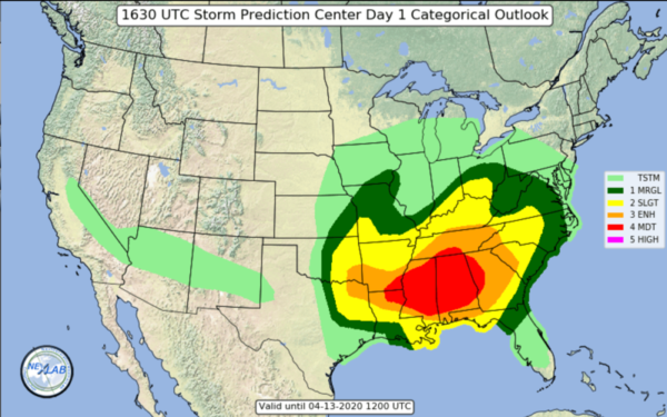
This is the second of four widely spaced forecast maps from the Storm Prediction Center (SPC). This one was released at 7am CDT Sunday morning. The third one comes out at 11:30am and the last one comes out at 3pm CDT. The area of MODERATE risk has expanded to cover more of the state of Alabama than the maps released yesterday. We all know storms don't read maps, but we also know that the threat parameters have expanded in size and scope. A moderate risk area this wide gives ample room for a potential upgrade in risk. I won't mention that here since neither the SPC nor the local office of the Birmingham National Weather Service (NWS) have even hinted at a potential upgrade.

Here in Birmingham Alabama we take a look at the details regarding timing at today’s severe weather threat.

The broad window of severe weather is indicative of a degree of uncertainty regarding timing and how many actual episodes of severe weather may impact us today. Current thinking is that at least two episodes will impact the Birmingham metro area today, one starting in the early afternoon and extending for some hours, and then one triggered by the approaching cold front later on today. The largest unknown parameter for severe weather is the predicted capping for this afternoon. Capping is forecast, but the strength of the cap is unknown at this time. Capping is when a temperature inversion "puts a lid on it" and prevents storms from expanding into the upper atmosphere. That expansion is necessary for a storm to become a supercell. The cap functions like the lid on a pressure cooker. When the cap "breaks" the storm explodes upward into uncontrolled growth and every mode of severe weather becomes possible as a supercell is created. Cap "breakage" can be forecast when weather balloons are released at different times in the day to access the upper air temperature profile
At this moment (10:10am Sunday morning) it appears that all is calm in Alabama except for a few discreet storms. May your Easter Sunday morning be a good one!
NEW UPDATE AT 11:30am
This is the 11:30am map. Note that MODERATE risk area spread into southern Tennessee.
The chances for wind damage are far higher than the chances for a tornado.
Here is the wind damage potential map.

"Probability of damaging thunderstorm winds or wind gusts of 50 knots or higher within 25 miles of a point.
Hatched Area: 10% or greater probability of wind gusts 65 knots or greater within 25 miles of a point."(note)
Here is the tornado potential.

Probability of a tornado within 25 miles of a point.
Hatched Area: 10% or greater probability of EF2 - EF5 tornadoes within 25 miles of a point. (More Info)
Please remain alert during this dynamic and potentially dangerous event.
Subscribe to:
Posts (Atom)